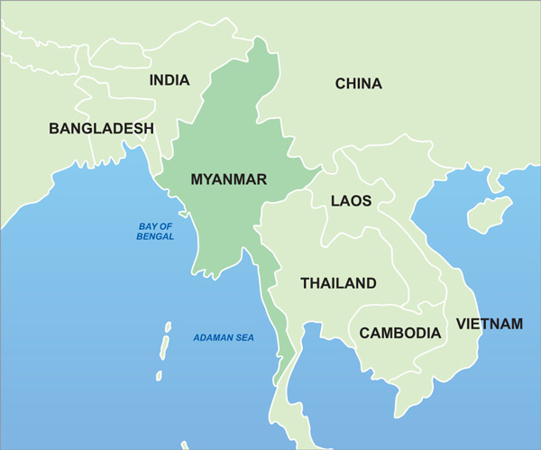
Location Myanmar is situated in southeast Asia and is bordered on the north and northeast by China; on the east and southeast by Laos and Thailand; on the south by the Andaman Sea and the Bay of Bengal; and on the west by Bangladesh and India. It is located between latitudes 09°32’N and 28°31’N and longitudes 92°10’E and 101°11’E. The country covers an area of 677,000 square kilometers (261,228 square miles) ranging 936 kilometers (581 miles) from east to west and 2,051 kilometers (1,275 miles) from north to south.
Geography The total area of Myanmar is 678,500 sq km where 657,740 sq km occupies the land and 20,760 sq km occupies the water. The bordering countries are Bangladesh 193 km, China 2,185 km, India 1,463 km, Laos 235 km, and Thailand 1,800 km. The central lowlands ringed by steep, rugged highlands The lowest point is the Andaman Sea (0 m) and the highest point Hkakabo Razi (5,881 m).
Climate Myanmar has three main seasons, hot season (summer), rainy season and cold season (winter). Hot season is from March to May, rainy season is from June to October and cold season is from November to February. The tropical monsoon is usually cloudy, rainy, hot, humid summers and less cloudy, scant rainfall, mild temperatures, lower humidity during winter.
Natural resources Myanmar is rich in natural resources such as petroleum, timber, tin, antimony, zinc, copper, tungsten, lead, coal, some marble, limestone, precious stones, natural gas, hydropower.
People Myanmar is made up of 135 national races, of which the main national races are Kachin (12), Kayah (9), Kayin (11), Chin (53), Bamar (9), Mon (1), Rakhine (7) and Shan (33). Population is estimated to be over 51 million according to the 2014 Census. The nationality is Myanmar.
Religion The religions are Buddhist (87.9), Christian (6.2), Islam (4.3), Hindu (0.5), Animist (0.8), Other (0.2), and Non (0.1).
Language The major language is Myanmar, but minority ethnic groups have their own languages. English is widely spoken and understood.
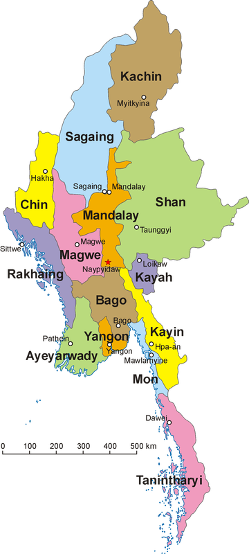
State, District, and Regions There are 7 States (Kachin, Kayah, Kayin, Chin, Mon, Rakhine, Shan), 7 Regions (Yangon, Bago, Magwe, Mandalay, Sagaing, Taninthayi, and Ayerawaddy) and 1 Union territory (Nyipyidaw) [Nyipyidaw is often added to Region], 74 Districts (Bago, Bawlakhe, Bhamo, Dawei, Detkhina, East Yangon, Falam, Gangaw, Hakha, Hinthada, Hkamti, Hopang, Hpa-An, Hpapun, Kale, Katha, Kawkareik, Kawthaung, Kengtung, Kunlong, Kyaukme, Kyaukpyu, Kyaukse, Labutta, Langkho, Lashio, Laukkaing, Loikaw, Loilen, Magway, Mandalay, Matman, Maubin, Maungdaw, Mawlaik, Mawlamyine, Meiktila, Minbu, Mindat, Mohnyin, Monghpyak, Monghsat, Monywa, Mrauk-U, Muse, Myaungmya, Myawady, Myeik, Myingyan, Myitkyina, North Yangon, Nyaung-U, Oketara, Pakokku, Pathein, Putao, Pyapon, Pyay, Pyinoolwin, Sagaing, Shwebo, Sittwe, South Yangon, Tachileik, Tamu, Taungyi, Taungoo, Thandwe, Thaton, Thayarwady, Thayet, West Yangon, Yamethin, and Yinmabin), 412 Township & Sub-township, 13,620 Village tracts, 3,133 Wards, and 63,938 Villages.
History The earliest primates known today as Pondaung Man, resided in Pondaung, northern Myanmar about 40 million years ago. After those era, many city states emerged, and then came the 3 empires. In the third century BC, Myanmar was already unified into one strong empire. The first Myanmar Empire was created by King Anawrahta of the Bagan Dynasty (1044-1077 AD). The second Myanmar Empire was created by King Bayinnaung of the Taungoo Dynasty (1551-1581 AD). The third Myanmar Empire was led by King Alaungpaya of the Konbaung Dynasty (1752-1760 AD). These three great kings were well-known in the Myanmar history for their bravery and good leadership. In 1885, King Thibaw, Queen Supaya Latt and the royal family were taken to Ratanagiri, India and Myanmar fell under the British Rule. Myanmar became a British Colony from 1885 until 1948.
Neighboring Countries Myanmar has many neighboring countries, Bangladesh is located in the West, India in the Northwest, China in the Northeast, Laos and Thailand in the East.
General Information
The country code is +95, and the internet access code is .mm.
Time Zone = MMT (UTC+6:30)
International airports are in Yangon and Mandalay.
The country is divided into states, divisions, townships, wards and villages.
Business Hours is usually from 9am to 5pm for private companies and 9:30-4:30 for government offices. Working days are from Monday through Friday. Public holidays are also included.
Major Credit cards are not widely accepted. Cash is always more convenient. National currency is Kyat.
Electricity is 200 volts AC, 50Hz.
Taxis are available everywhere. There are over 250 Buses lines running through Yangon everyday. For exclusive transport, there are car rental services.
Domestic highway bus terminals are Aung-Yadanar and Sawbwargyi-Gone, both about 10 miles from downtown Yangon.
Common local unit of weight is peiktha (viss), which equals to 3.6 pounds.
Most common unit of measure is feet and inches.
Clothing should be light, casual cotton wear, sandals or slippers are best for summer.
A cardigan or light jerkin for winter and quick drying clothes and an umbrella during the rainy season.